Description
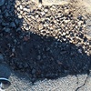
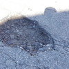
This entire section of Slade Street looks like an airstrip that was bombed. Too many holes to list individually.
also asked...
Q. What is the exact location of the pothole, i.e., address and location on pavement? What is the approximate size of the pothole? If applicable, please add any additional location information (landmarks, intersections, etc.).
A. Slade St. between Kilburn St. and Route 81
A. Slade St. between Kilburn St. and Route 81


2 Comments
Mayor's Office (Registered User)
Closed BayB33 (Registered User)